Zusammenfassung
Venezuela betreibt eines der ausgefeiltesten Sanktionsumgehungs-Oekosysteme der Welt, das sowohl den maritimen als auch den Luftfahrtbereich umfasst. Durch eine Kombination aus alternden „Dark-Flotte“-Tankern, staatseigenen PDVSA-Schiffen, lizenzierten Chevron-gecharterten Schiffen und einer Konstellation privater und regimeverbundener Flugzeuge hat die bolivarische Regierung parallele Logistiknetzwerke fuer Oelexporte und Drogenhandel aufgebaut, die weitgehend ausserhalb internationaler Aufsicht operieren. Diese Ermittlung katalogisiert ueber 70 Seeschiffe und 60+ Flugzeuge, die durch Open-Source-Intelligence von ODINT identifiziert wurden, klassifiziert nach operativer Rolle und Risikoprofil.
Die Dark Flotte — Maritime Sanktionsumgehung
Was ist die Dark Flotte…
Die „Dark Flotte“ (auch „Schattenflotte“ oder „Geisterflotte“ genannt) bezeichnet ein globales Netzwerk alternderer Oeltanker, die Rohoel aus sanktionierten Laendern transportieren — hauptsaechlich Russland, Iran und Venezuela — und dabei internationale Verfolgungs- und Versicherungsrahmen umgehen. Diese Schiffe teilen gemeinsame Merkmale:
- Alte Tonnage: Die meisten sind 15–25 Jahre alt, weit ueber dem Alter, das von etablierten Versicherern und Klassifikationsgesellschaften akzeptiert wird.
- Undurchsichtige Eigentuemerstruktur: Registriert ueber Briefkastenfirmen in Jurisdiktionen wie den VAE, Seychellen, Liberia und Hongkong.
- Flagges of convenience: Registriert in Guinea, den Komoren, Panama, Togo, Kamerun, Bolivien und anderen Regulierungshäfen, die nur minimale Aufsicht bieten.
- Keine westliche P&I-Versicherung: Betrieb ohne die Schutz- und Entschaedigungsdeckung, die von grossen Haefen und der International Group of P&I Clubs verlangt wird.
Die Schattenflotte wuchs im Jahr bis Mitte 2025 um etwa 45%, angetrieben hauptsaechlich durch die kaskadierenden Sanktionen des Russland-Ukraine-Krieges. Schaetzungen zufolge waren 218 Tanker an Venezuela-bezogenen Rohoelbewegungen in einem einzigen 12-Monatszeitraum beteiligt, wobei fast 80% mindestens eine „dunkle Aktivitaet“ aufwiesen. Unter Einbeziehung von Schiff-zu-Schiff-Transfers (STS) koennten bis zu 10% der weltweiten Tankerflotte mit dem venezuelanischen Frachttransport verbunden sein.
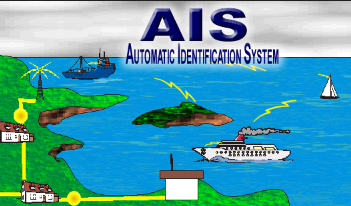
AIS-Manipulation und taeuschende Schifffahrtspraktiken
Die in dieser Ermittlung verfolgten Schiffe setzen mehrere Ebenen elektronischer Taeuschung ein:
| Technik | Beschreibung | Erkennungsmethode |
|---|---|---|
| Going Dark | Besatzung deaktiviert manuell den AIS-Transponder, wodurch Signalluecken entstehen | Algorithmische Lueckenanalyse; Satelliten-SAR-Bilder |
| AIS Spoofing | Falsche Koordinaten gesendet, um das Schiff digital in sicheren Gewaessern zu platzieren, waehrend es physisch an sanktionierten Terminals beladen wird | Abgleich von AIS mit Satellitenbildern (Sentinel-1, kommerzielles SAR) |
| Circle Spoofing | Automatisierte Software erzeugt gefaelschte kreisfoermige Wartemuster | Geometrische Anomalieerkennung |
| GNSS Manipulation | Falsche GPS-Koordinaten in das Transpondersystem des Schiffs eingespeist, wodurch es ueber Ozeane „springen“ kann | Multi-Quellen-Korrelation (Kpler, TankerTrackers, Satellit) |
| Identity Laundering (“Zombie” Vessels) | Betreiber erwerben MMSI-Nummern von verschrotteten Schiffen und programmieren sie in aktive Tanker | IMO-Querverweise mit Scraping-Datenbanken |
| Flagge Hopping | Schnell wechselnde Registrierung zwischen Billigflaggen, um regulatorische Schwarze Listen zu ueberholen | Analyse der Häufigkeit von Flaggenzustandsänderungen |
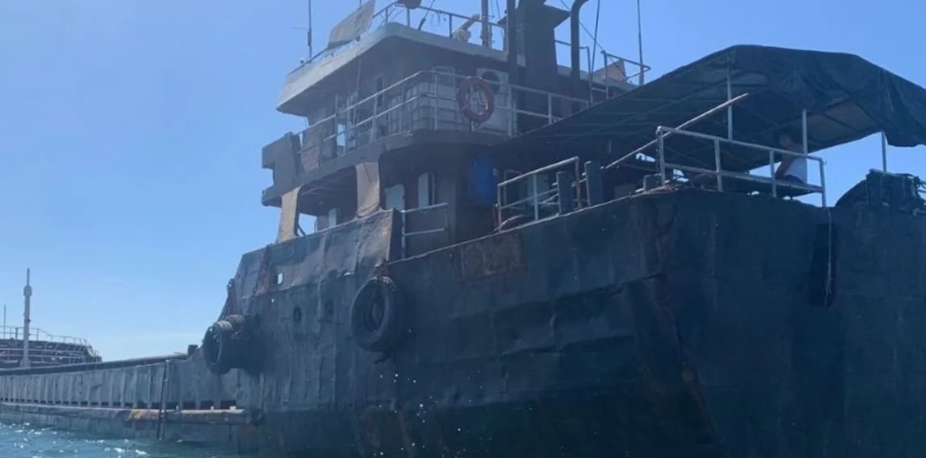
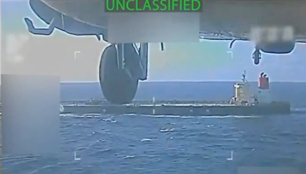
Ein markantes Beispiel: Als US-Streitkraefte am 10. Dezember 2025 den VLCC Skipper vor der venezolanischen Kueste beschlagnahmten, sendete sein AIS-Transponder Koordinaten, die ihn nahe Guyana und Suriname plazierten — 500 Seemeilen von seiner tatsaechlichen Position am venezolanischen José-Terminal, wo Satellitenbilder bestaetigten, dass er sanktioniertes Rohoel lud.
ODINT-Schiffskatalog
Sanktionierte Schiffe
Die folgenden Schiffe wurden durch Ueberwachung als sanktioniert durch eine oder mehrere Instanzen von OFAC (USA), OFSI (UK) oder der Europaeischen Union identifiziert und wurden bei Operationen in oder nahe venezolanischen Gewaessern beobachtet:
| Schiffsname | IMO | MMSI | Flagge | Sanktionen | Wichtige Informationen |
|---|---|---|---|---|---|
| XANTHOS EOS | 9231212 | 306761000 | Curaçao/Panama | OFAC, EU, UK | Arrived Amuay mid-September 2025; previously transported Russian crude; owned by Merluza Group Limited (sanctioned Jan 2025) |
| TITAN SPIRIT | 9412905 | — | — | Sanktionen/OSINT listed | Tracked in Middle East–Caribbean corridor; last seen near UAE waters Sep 2025 |
| HAPPY LADY | 9005479 | — | — | Sanktionen coverage | Tracked in Mediterranean/Eastern routes; last AIS signal Sep 2025 |
| GRACE 1 | 9116412 | — | — | Historical sanctions | Der iranische Supertanker wurde im Juli 2019 von Gibraltar festgehalten, während er 2 Millionen Barrel Rohöl für Syrien transportierte; wurde zum Symbol der Durchsetzung von Sanktionen |
| AMUAY SENTINEL | 9422210 | — | — | Sanctioned/alias tracking | Arrivals at Paraguaná peninsula auditable; last seen Sep 2025 |
| CARDON SENTINEL | 9422211 | — | — | Sanctioned/dual verification | Arrivals at Cardón refinery complex; last seen Sep 2025 |
Dark-Flotte-Schiffe (Unbestaetigt/ODINT-verfolgt)
Diese Schiffe wurden durch ODINT-Ueberwachung in karibischen Gewaessern mit Verhaltensanomalien identifiziert, die mit Dark-Flotte-Operationen uebereinstimmen:
| Schiffsname | IMO | Kategorie | Zuletzt bekannte Position | Wichtige Anmerkungen |
|---|---|---|---|---|
| VERNAL (ALT) | 9232888 | Dunkle Flotte | 24.90°N, 56.30°W (UAE area) | Shadow fleet; UK/EU sanctions; alias tracking |
| KOALA (ALT) | 9230423 | Dunkle Flotte | 26.20°N, 55.80°W | Schattenflotte; Identitätswechsel 2025 |
| PHOENIX VOYAGER | 9245678 | Dunkle Flotte | 11.90°N, 66.50°W (Caribbean) | OSINT-tracked Caribbean operations |
| ODYSSEY | 9234567 | Dunkle Flotte | 12.00°N, 70.90°W | Caribbean Dark Flotte activity |
| MIRAGE | 9234568 | Dunkle Flotte | 11.50°N, 69.80°W | Caribbean Dark Flotte activity |
| ORION | 9234569 | Dunkle Flotte | 12.20°N, 64.50°W | Caribbean Dark Flotte activity |
| BALTIC SUN | 9302145 | Dunkle Flotte | 12.50°N, 60.80°W | Listed by NGOs |
| ARCTIC SEA | 9302146 | Dunkle Flotte | 13.10°N, 57.00°W | Listed by NGOs |
| NORDIC SKY | 9302147 | Dunkle Flotte | 14.20°N, 55.50°W | Listed by NGOs |
| BLACK PEARL | 9302148 | Dunkle Flotte | 15.10°N, 53.20°W | Listed by NGOs |
| RED SEA | 9302149 | Dunkle Flotte | 16.00°N, 51.10°W | Listed by NGOs |
| CUBAN ALLY | 9309981 | Dunkle Flotte | 19.80°N, 75.80°W (Cuba) | Cuba resupply via Dark Flotte |
| GULF TRADER | 9317782 | Dunkle Flotte | 20.00°N, 75.00°W | Venezuela–Cuba STS routes 2024/2025 |
Von besonderer Bedeutung sind die Schiffe nach Kuba. Das venezolanische Regime nutzt ein geheimes Netzwerk von Tankern, um Rohöllieferungen nach Havanna aufrechtzuerhalten. Ein einziger unter kubanischer Flagge fahrender Tanker transportierte in einem Monat über 300.000 Barrel aus Venezuela – weit mehr als die offiziellen Exportzahlen.
ODINT uses its own tools to track these vessels
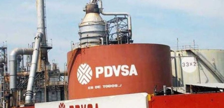
PDVSA State Flotte
Venezuela’s state oil company PDVSA operates its own fleet of tankers through its subsidiary PDV Marina, ergänzt durch Schiffe unter ausländischer Flagge unter Exklusivcharter. Diese Schiffe transportieren Rohöl zwischen den acht großen Ölhäfen Venezuelas (José, Amuay, Cardón, Puerto La Cruz, El Palito, Bajo Grande und andere) und wickeln Exportladungen ab:
| Schiffsname | IMO | Terminal/Region | Last Seen | Anmerkungen |
|---|---|---|---|---|
| CARABOBO | 9524114 | Falcón/Zulia | — | PDVSA fleet; multiple port calls |
| TAMANACO | 9524102 | — | — | PDVSA fleet |
| NEGRA HIPOLITA | 9274356 | — | — | PDVSA fleet |
| CUMANÁ II | 9303153 | Puerto La Cruz | Sep 3, 2025 | 10.46°N, 64.19°W |
| LLANOS | 9303101 | Western Venezuela | Sep 4, 2025 | Export window Sep 2025; 10.70°N, 71.60°W |
| ANACO II | 9303127 | PLC–El Palito | Sep 3, 2025 | Activity surge Sep 2025 |
| CARIPITO | 9303139 | Eastern Venezuela | Sep 2, 2025 | PDVSA Oriente |
| PARIA BAY | 9303164 | Eastern Caribbean | Sep 5, 2025 | STS transfer zone |
| PUERTO MIRANDA | 9303145 | Gulf of Venezuela | Apr 28, 2025 | Queuing delays reported Apr 2025 |
The full PDVSA fleet catalog includes dozens of additional vessels (PITIGUAO, MORICHAL, BOYACA, MARA, CATATUMBO, ZULIA, GUAJIRA, CUMAREBO, PUNTA CARDON, AMUAY BAY, SAN FELIX, ANZOATEGUI, ORINOCO, CARIBE, LA GUAIRA, PUERTO CABELLO, PUERTO SUCRE, LOS ROQUES, and others). Ten foreign-flagged vessels were found sailing exclusively between Venezuela’s eight oil ports on behalf of PDV Marina, most registered in Panama and Comoros by shipping companies from the UAE.
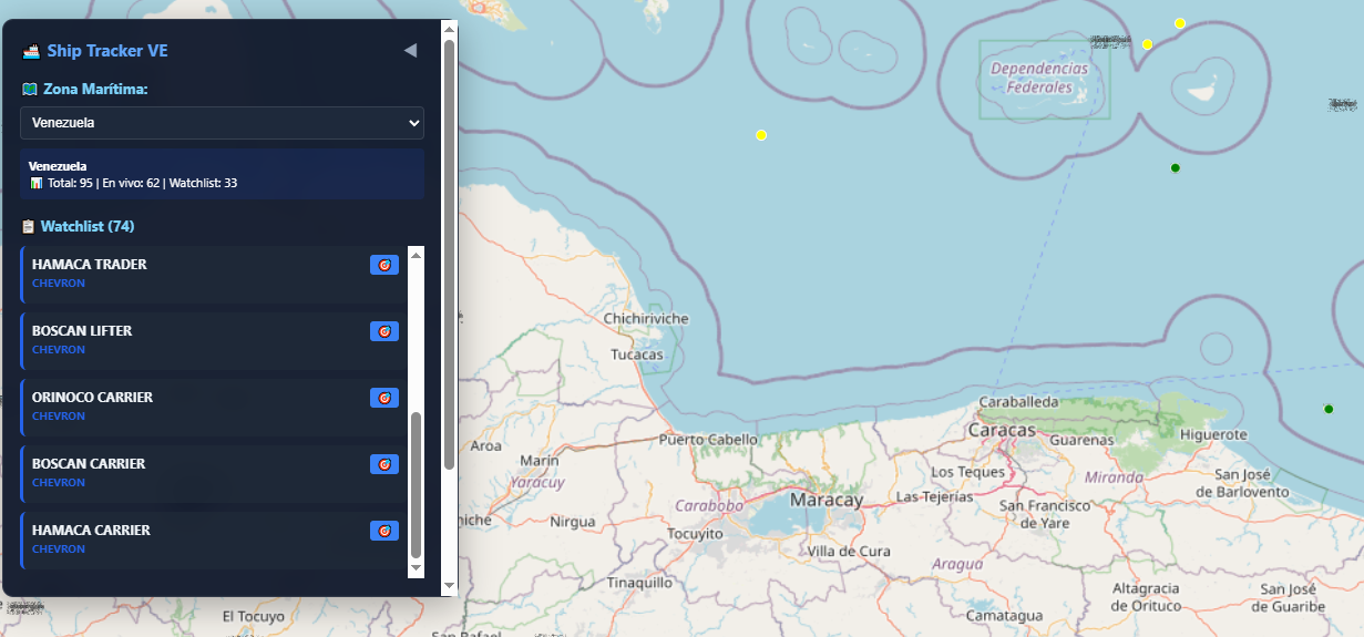
Chevron-Licensed Vessels
Nach der eingeschränkten US-Lizenz, die Chevron im Juli 2025 erteilt wurde, nahm eine Tankerflotte den Betrieb an venezolanischen Terminals wieder auf.
| Schiffsname | IMO | Flagge | Wichtige Informationen |
|---|---|---|---|
| CANOPUS VOYAGER | 9452227 | Bahamas | Erste Verladung von schwerem Hamaca-Rohöl unter neuer Lizenz am 12. August 2025 am José-Terminal |
| MEDITERRANEAN VOYAGER | 9411975 | Bahamas | Loaded Boscán heavy crude at Bajo Grande, Aug 2025 |
| CANOPUS VOYAGER II | 9452239 | — | Chevron-chartered window Aug–Sep 2025 |
| MEDITERRANEAN VOYAGER II | 9411987 | — | Chevron-chartered flow Aug 2025 |
| HAMACA TRADER | 9430021 | — | Loading Hamaca crude post-license |
| BOSCAN LIFTER | 9427765 | — | Loading Boscán crude post-license |
| ORINOCO CARRIER | 9345670 | — | Chevron/PDVSA flows Aug–Sep 2025 |
Zu den weiteren von Chevron gecharterten Schiffen in der Einsatzflotte gehören BOSCAN CARRIER, HAMACA CARRIER, GEORGE T, SEA LION, AVON, HIGHLANDER, POINT FORTIN, NABUCCO, CARIBBEAN PIONEER, CEDAR, MONGOOSE, PEREGRINE, HARRIER, FALCON und CONDOR. Reuters- und LSEG-Daten bestätigten, dass im August 2025 mindestens fünf Schiffe gleichzeitig in venezolanische Gewässer fuhren, wobei weitere Schiffe in Aruba anlegten – einem gemeinsamen Knotenpunkt für Schiff-zu-Schiff-Transfers venezolanischen Rohöls.

Die Narco-Flugzeuge — ODINT-Luftfahrt
Venezuela als Narco-Aviation-Hub
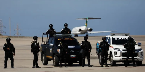
Venezuela dient seit langem als wichtiger Lufttransitkorridor für kolumbianisches Kokain auf dem Weg nach Nordamerika, Mittelamerika und in die Karibik. Seit 2019 haben die venezolanischen Streitkräfte offiziell mindestens 21 Flugzeuge auf dem Territorium des Landes zerstört – zwölf davon waren nachweislich in den USA registriert. Laut offiziellen Angaben des venezolanischen Militärs stieg diese Zahl bis zum Jahr 2025 auf mindestens 39 „Drogenflugzeuge“, die allein in diesem Jahr neutralisiert wurden.
Das Cartel de los Soles ermöglicht diesen Luftkorridor durch ein Netzwerk korrupter Militäroffiziere, die Abflüge und Ankünfte von Drogenflugzeugen genehmigen, die Luftradarabdeckung verwalten, um „tote Winkel“ zu schaffen, und geheime Landebahnen in Grenzregionen kontrollieren. Der Pilot der ehemaligen First Lady Cilia Flores, Yazenky Lamas, wurde an die Vereinigten Staaten ausgeliefert, weil er Flugverkehrscodes bereitgestellt hatte, die es Kokainflugzeugen erlaubten, sich als kommerzielle Flüge auszugeben – er wurde mit „Hunderten von Drogenflügen“ in Verbindung gebracht.
Regime und Staatsflugzeuge
The ODINT-tracked aircraft catalog reveals a complex hierarchy of state, regime, and private aviation assets:
Präsidenten- und Führungsflotte
| ICAO/Registrierung | Beschreibung | Significance |
|---|---|---|
| T7102X | Neues Maduro-Flugzeug (Ersatz für beschlagnahmtes Flugzeug) | Acquired after the U.S. seized two Dassault Falcon jets linked to Maduro in 2024–2025. The original YV3016/YV3360 aircraft were seized in the Dominican Republic |
| YV2984 | Presidential/entourage aircraft | Listed on OFAC’s SDN list as Conviasa blocked property since 2020 |
| YV1004 | Entourage-Flugzeug des Regimes | Conviasa SDN-listed |
| T777PR | PDVSA-purchased; Díaz-Canel Cuba flights | Wird für den Transport des kubanischen Präsidenten Miguel Díaz-Canel verwendet |
| YV654T | “Gift” to Díaz-Canel — Gulfstream G2 | Regimeflugzeuge als diplomatisches Geschenk an Kuba übergeben |
| YV3119 | Diosdado Cabello zugeschriebenes Flugzeug | Cabello wird von den USA mit einem Kopfgeld von 25 Millionen US-Dollar bestraft; jetzt Innenminister, der die Anti-Drogen-Operationen überwacht |
The seizure of Maduro’s aircraft represents a critical OSINT milestone. In September 2024, U.S. authorities seized a Dassault Falcon 900 described as “Venezuela’s Air Force One,” which had been purchased for $13 million through a Briefkastenfirma in violation of sanctions. In February 2025, Secretary Rubio personally oversaw the seizure of a second Dassault Falcon 2000EX (YV-3360) in Santo Domingo, which yielded intelligence including transponder data, flight manifests, and Venezuelan Air Force personnel records.
CONVIASA — The Sanctioned State Airline
CONVIASA (Consorcio Venezolano de Industrias Aeronáuticas y Servicios Aéreos) was designated under Executive Order 13884 in August 2019 and formally added to the SDN list in February 2020. The U.S. accused the airline of shuttling regime officials to North Korea, Cuba, and Iran. The OFAC listing includes 37+ aircraft: Airbus A319/A340, Boeing 737s, ATR42/72s, Embraer ERJ190s, Cessna 208 Grand Caravans, and DHC-7s.
Notable CONVIASA-linked tracked aircraft:
- YV3397: Ex-Conviasa, sanctioned; tracked to Isla Tortuga — a small Venezuelan island historically associated with clandestine operations
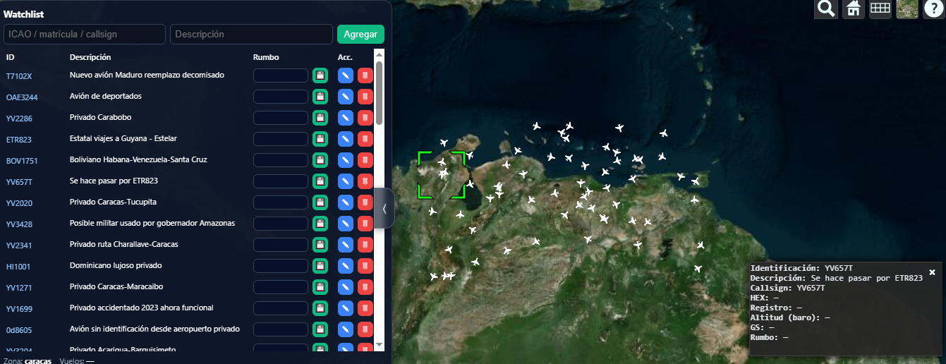
- ETR823/ETR8949H: Flugzeuge der Fluggesellschaft Estelar mit unregelmäßigem Verhalten; Die mit dem Staat verbundene Fluggesellschaft betreibt Guyana-Strecken
DGCIM Military Intelligence Aircraft
| Registrierung | Beschreibung | Route/Pattern |
|---|---|---|
| YV2770 | DGCIM (Directorate General of Military Counterintelligence) | Flüge des militärischen Geheimdienstes des Regimes |
| YV2707 | DGCIM | Militärische Geheimdienstoperationen |
| YV2875 | DGCIM plant aircraft | Barinas-Route – Grenzstaat zu Kolumbien |
| YV3086 | Militär | Militärflugplatz La Carlota nach Porlamar (Insel Margarita) |
| AMB0222 | Militär | Flugplatz La Carlota – wichtigstes militärisches Luftfahrtdrehkreuz in Caracas |
Entourage und politische VIP-Flotte
The ODINT data reveals a substantial fleet of private aircraft dedicated to regime VIP transport:
- YV3554, YV3399, YV3226, YV3218, YV3006, YV2630, YV3381, YV3562: Politische Begleitflugzeuge, die für Reisen des Regimes im Inland eingesetzt werden
- YV1794: High-frequency regime usage
- YV2689: Berichten zufolge werden Regimeflugzeuge von eingesetzt Kimberly Delgado — a politically connected figure
- YV3173: Linked to Aristóbulo Istúriz faction / Barquisimeto chavistas
ODINT uses its own tools to track suspicious aircraft in Latin America
Mit Drogen in Zusammenhang stehende und verdächtige Flugzeuge
Indikatoren für Drogenhandel und Goldschmuggel
| Registrierung | Beschreibung | Risk Assessment |
|---|---|---|
| YV3088 | Unknown — Guyana narco/gold route | Die Grenzregion zu Guyana ist das Epizentrum des illegalen Bergbaus und des Gold-gegen-Drogen-Handels |
| YV3457 | Unknown — Mexico narco/gold route | Mexiko-Korridor für Drogen- und Goldwäsche |
| YV3025 | Regime — gold, Ciudad Guayana | CVG (Corporación Venezolana de Guayana) mineral extraction zone |
| YV0138 | CVG minerals-related | Verbunden mit staatlichen Bergbaubetrieben im Bundesstaat Bolívar |
| YV3514 | Internationaler Drogenhandel; dem US-Militär übergeben | Das einzige Flugzeug im Katalog mit bestätigter militärischer Beteiligung der USA |
| YV3379 | Guanare-Route – Verdacht auf Drogen | Bundesstaat Portuguesa – bekannter Drogentransitkorridor von der kolumbianischen Grenze aus |
| YV3044 | Seltene Route nach Guayana | Süd-Venezuela – Bergbau- und Handelszone |
Geisterflugzeuge und Identitätsmanipulation
| Identifier | Beschreibung | OSINT Concern |
|---|---|---|
| 0d8605 | No identification — private airfield departure | Hex code only; no registration data — maximum opacity |
| e48cbd | Brasilianische Flugzeuge – keine Informationen | Unresolved foreign hex code operating in Venezuelan airspace |
| 0d8487 | Entspricht YV654T – Geschenkflugzeug des Regimes | Duplicate hex suggesting transponder manipulation or identity laundering |
| YV657T | Impersonating ETR823 (Estelar) | Aktives Transponder-Spoofing: Ein Privatflugzeug sendet die Identität einer Fluggesellschaft, um einer Überprüfung zu entgehen |
| YV3089 | Rare — no hex code | Operating without any digital footprint |
Der Fall von YV657T impersonating ETR823 spiegelt maritime AIS-Spoofing-Taktiken wider: Ein Privatflugzeug gibt die Identität eines kommerziellen Flugs der Estelar Airlines weiter, um dessen wahre Natur zu verschleiern. Diese Technik wurde in der Anklage gegen Yazenky Lamas dokumentiert, wo Drogenpiloten Flugverkehrsregeln nutzten, um kommerzielle Flüge vorzutäuschen.
International Routes of Concern
| Registrierung | Route | Significance |
|---|---|---|
| BOV1751 | Havana–Venezuela–Santa Cruz (Bolivia) | Trinationaler Drogenkorridor, der die Kokaanbaugebiete Kubas, Venezuelas und Boliviens verbindet |
| OAE3244 | Abgeschobenes Flugzeug | UAE-linked transport |
| HI1001 | Dominican Republic — luxury private | Die DR war ein Schauplatz für die Beschlagnahmung von Flugzeugen durch das Regime |
| HI1045 | Dominikanische Republik – von Guaidó verwendet | Mit der Opposition verbundene Flugzeuge |
| YV2853 | EXC2853 — Regime, Lesser Antilles | Insel-Hopping-Route durch die östliche Karibik |
| YV3404 | Constant flights to Cuba | Kuba-Nachschubkorridor – spiegelt die maritime Route der Cuba Dark Flotte wider |
| YV2692 | Regime — USA–Venezuela flights | Aktive Route USA–Venezuela trotz Sanktionen |
| YV1106 | Seltene Route USA–Venezuela | Ungewöhnliche Flugaktivität zwischen den USA und Venezuela |
| YV147T | Private CCS–Curaçao | Caracas nach Curaçao – gemeinsamer Offshore-Finanzierungs- und STS-Transferknotenpunkt |
| AVA018 | Avianca-Verkehrsflugzeuge, die von der Umgebung genutzt werden | Kommerzielle Luftfahrt wird für den VIP-Transport des Regimes genutzt (hex: aace63) |
Konvergenz – Wo die dunkle Flotte auf die Narco-Flugzeuge trifft
Das Cartel de los Soles Nexus
Die in dieser Untersuchung dokumentierten See- und Luftfahrtnetzwerke sind keine parallelen Systeme – sie sind integrierte Bestandteile desselben staatskriminellen Apparats. Die USA haben das Cartel de los Soles im November 2025 als ausländische Terrororganisation eingestuft. Aber es war nicht nur das Kartell, das diesen Korridor nutzte; Auch verschiedene Regierungen nutzten es zur Ausbeutung von Ressourcen, darunter auch die Vereinigten Staaten:
- Maritime corridors: Militäroffiziere genehmigen Schiffsabfahrten, verwalten den Hafenzugang und stimmen sich mit den Betreibern der Dunklen Flotte ab, um sanktioniertes Rohöl zu exportieren.
- Aerial corridors: Dieselben militärischen Strukturen verwalten die Radarabdeckung, erteilen Flugverkehrsregeln und betreiben geheime Landebahnen, um Drogenflüge zu erleichtern.
- Shared logistics: The Cuba-bound supply chain operates through both maritime (Dark Flotte tankers like CUBAN ALLY and GULF TRADER) and aviation (YV3404 constant Cuba flights, T777PR PDVSA-Cuba, YV654T Díaz-Canel aircraft) channels.
Key Geographic Nodes
The ODINT data clusters around several critical nodes:
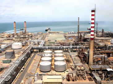
- Paraguaná Peninsula (Amuay/Cardón): Venezuela’s largest refinery complex; arrival point for sanctioned tankers like XANTHOS EOS
- José Terminal (Anzoátegui): Primäres Rohölexportterminal; wo die Skipper wurde geladen, als es beschlagnahmt wurde
- Gulf of Venezuela / Lake Maracaibo: Westliche Ölexportzone und Abfangkorridor für Drogenflugzeuge
- Paria Peninsula / Eastern Caribbean: STS-Transferzone für Schiffe der Dark Flotte
- Aruba / Curaçao: Bereitstellungsbereich für Chevron STS-Transfers und Dark Flotte-Operationen
- Ciudad Guayana / Bundesstaat Bolívar: Goldabbaugebiet; Hier operieren die Flugzeuge YV3025, YV3088, YV0138
- Cuba: Ziel sowohl für Öltanker der Dunklen Flotte als auch für Flugzeuge des Regimes
Die VAE-Verbindung
Ein wiederkehrendes Muster sowohl in der Schifffahrt als auch in der Luftfahrt: den Vereinigten Arabischen Emiraten dient als primärer Unternehmenshafen für die Sanktionsumgehungs-Infrastruktur. Allein Asia Charm Limited FTZ betreibt 13 Tanker in venezolanischen Gewässern, und mehrere andere in den Vereinigten Arabischen Emiraten ansässige Unternehmen (Kroeger Tankers, Julius Capital, Issa Shipping) verwalten sanktionierte oder getarnte Schiffe. Das regulatorische Umfeld der VAE hat es ermöglicht, diese Operationen trotz internationaler Kontrolle fortzusetzen.
Was ODINT aufdeckt
The ODINT data cataloged here reveals the industrial scale of Venezuela’s dual-use logistics network. Over 70 maritime vessels span the full spectrum from sanctioned Dark Flotte tankers to state-owned PDVSA ships to licensed Chevron operations, while 60+ aircraft range from presidential jets to unidentified ghost planes on narco-trafficking routes. The convergence point is the Venezuelan state itself—through the Cartel de los Soles, the same military command structure that manages oil port access also controls aerial radar and clandestine airstrips.
Aber es entlarvt auch Regierungen auf allen Seiten: Russland, Iran, die Vereinigten Staaten und sogar die Vereinigten Arabischen Emirate nutzten den Handelskorridor und werden dies auch weiterhin tun, um sich den Reichtum Venezuelas zunutze zu machen.
Die Durchsetzungskampagne der USA – von der Beschlagnahmung von Tankern bis hin zur FTO-Einstufung – hat diese Netzwerke zwar gestört, aber nicht zerschlagen. Der Ausbruch von 12 beladenen Tankern im Dunkelmodus im Januar 2026 zeigt, dass sich die Dunkelflotte schneller anpasst, als die Durchsetzungsmaßnahmen verfolgen können. In der Luftfahrt hingegen deutet die Fähigkeit des Regimes, Ersatzflugzeuge zu beschaffen (T7102X nach den Dassault-Beschlagnahmungen), Transponderidentitäten zu fälschen (YV657T, das sich als ETR823 ausgibt) und ständige Flüge nach Kuba aufrechtzuerhalten (YV3404), auf ein System hin, das vor allem auf Widerstandsfähigkeit ausgelegt ist.
Investigator's Note
This report is based entirely on open-source intelligence (OSINT). No classified information was accessed. No confidential sources were used. Everything documented here is publicly available — if you know where to look.